14.3 Has Arrived!

We’re excited to announce the release of ThinkGeo UI 14.3, a major update packed with new features and performance enhancements for your mobile, desktop and web applications.
Highlights include real-time reprojection for web-based raster XYZ layers, support for Mapbox Vector Tiles with JSON styling, smoother animations, dynamic map rotation, and improved performance on 4K monitors. Touchscreen users will also benefit from significantly enhanced touch interaction.
For a detailed list of all updates and improvements, check out the changelogs below:
Animations and Dynamic Rotation in WPF and Winforms
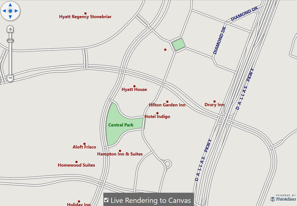
Figure 1 - Map rotation with dynamic label rendering directly to the canvas
Version 14.3 introduces direct-to-canvas rendering for our WPF and WinForms controls, enabling smoother animations - ideal for features like map rotation or vehicle navigation.
In Figure 1, you’ll see this in action: the user rotates the map by holding the <Alt> key while panning. Labels are smoothly redrawn with correct orientation, fully respecting the label overlap rules defined in your code.
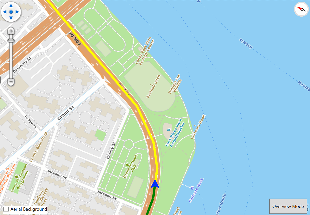
Figure 2 - Smooth vehicle navigation with direct-to-canvas rendering.
Figure 2 shows our WPF vehicle navigation sample in action. It uses direct-to-canvas rendering to display real-time vehicle movement with no lag or stuttering.
You can explore the code and run both samples locally by pulling the source from here. Stay tuned for an upcoming blog post where we’ll dive deeper into this new functionality!
Enhanced XYZ Layers
This release brings significant improvements to all web-based XYZ layers across all platforms. You'll see faster performance with MBTiles, WMTS, MVT, and other XYZ-based layers - plus, you can now reproject raster-based XYZ layers on-the-fly!

Figure 3 - WMTS Service reprojected on the fly from CRS 21781 to 4326 (decimal degree)
This is a game-changer for developers and allows you to build applications in any projection without needing to convert your custom datasets to match your online basemap provider.
Figure 3 shows a WMTS service reprojected from CRS 21781 to CRS 4326 using just a few lines of code.
We’ve also introduced a new "Render Beyond Max Zoom" feature, which lets you zoom in beyond the maximum zoom level supported by your XYZ data provider.
To see it in action, just pull the sample from our GitLab repo. And stay tuned for a future blog post where we’ll showcase the full range of improvements to XYZ layers.
New API for Pre-Caching and Custom TileMatrixSet
Despite advances in wireless connectivity, more developers are building and deploying offline applications. While tile caching has long been supported, version 14.3 brings a new API that makes it easy to programmatically cache map tiles.
The API is simple to use at either the Overlay or Layer level and is supported across Desktop, Mobile, and Web platforms. A preview of the streamlined pre-cache workflow is shown below:
  // Using the LayerOverlay, generate the cache for the current and the next 2 zooms.
  var zoom = _layerOverlay.TileMatrixSet.GetSnappedZoomIndex(MapView.CurrentScale);
  await _layerOverlay.GenerateTileCacheAsync(_bbox, zoom, zoom + 3, scaleFactor);

  // Using the OpenStreetMapAsyncLayer, generate a tile cache for a given bounding box and zoomlevels 0-4
  var northAmericaExtent = new RectangleShape(-20030000, 20030000, 0, 0);
  await _openStreetMapAsyncLayer.GenerateTileCacheAsync(northAmericaExtent, 0, 4);
In addition to the new pre-caching API, this release intruduces a custom TileMatrixSet to work with any scale provided by custom WMTS or XYZ tile services. No matter where your data is hosted, we can deliver it to the client at the scale that best fits your application. We will have a detailed blog post on this topic in the near future.
Support for Mapbox Vector Tiles (MVT)
Over the years, more customers have asked for support for Mapbox Vector Tiles (MVT) within a native .NET environment - complete with full offline capability. With today’s 14.3 release, that’s now possible!
Check out our HowDoI Samples to see the new MVT layer in action, and stay tuned for an upcoming blog post that will walk you through using MVT in your applications.
Performance Enhancements, Optimized Memory Usage and Touchscreen Improvements
This release also delivers broad performance improvements and optimized memory usage - especially on high-resolution displays.
Touchscreen users will also see major gains in responsiveness and freehand drawing. Check out the video to the right to see it in action.
We’ve included several bug fixes and stability enhancements as well. Thanks to our users for reporting issues through the community forums and helpdesk - your feedback helps make ThinkGeo better.
We Welcome Your Feedback
We hope you found today’s post useful. If you have questions or topics you'd like us to cover in future posts, we’d love to hear from you! Email us at sales@thinkgeo.com or schedule a meeting to talk in person. We always enjoy connecting with our customers, learning how you’re using ThinkGeo, and exploring new ways to improve our products.
About ThinkGeo

We are a GIS software company founded in 2004 and located in Frisco, TX. Our clients are in more than 40 industries including agriculture, energy, transportation, government, engineering, IT, and defense.
We pride ourselves on our excellent service and transparency. ThinkGeo offers a variety of products and services to meet almost any GIS application need. We can even help you develop your next project - anywhere from a few hours of consulting to outsourcing an entire project. To learn more, email us at sales@thinkgeo.com, or call us direct at 1-214-449-0330.