
Improved Geocoding from ThinkGeo Cloud
ThinkGeo Cloud has launched an upgraded geocoding platform that delivers more accurate results with significantly faster response times.
The new service combines multiple address and location datasets to provide broader coverage and better matching. In our testing, the upgraded geocoder is typically three to five times faster than the previous service, making it especially valuable for interactive searches, batch geocoding, and applications that process large numbers of addresses.
New Geocoding Endpoints
The upgraded services are available through the following endpoints:
Geocode (GET): /api/v3/location/geocode/{searchText}
Bulk Geocode (POST): /api/v3/location/multi-geocode
Reverse Geocode (GET): /api/v2/location/reverse-geocode/{pointY},{pointX}
Bulk Reverse Geocode (POST) /api/v2/location/reverse-geocode/multi
You can review and test these endpoints using the links above - just click the Authorize button and enter your ThinkGeo Cloud credentials. Then, click the Try It Out button for the endpoint that you want to try out.
.NET and JavaScript Samples
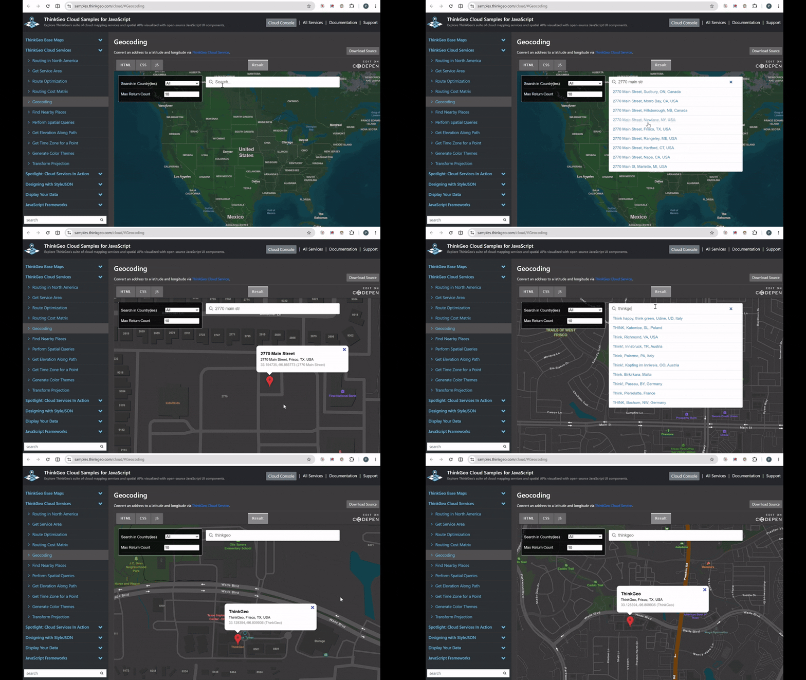
Javascript Geocoding Sample searching addresses and business names.
Developers can begin using the upgraded geocoder using ThinkGeo’s .NET client libraries or the available JavaScript api.
Support for the new endpoints is included in ThinkGeo 15.0.0 Beta 102 and newer. Existing .NET applications can upgrade the ThinkGeo.Core package and use the updated client APIs to access the new geocoding and reverse-geocoding services.
The samples below demonstrate how to submit searches, process geocoding results, reverse geocode coordinates, and display returned locations within a map application:
ThinkGeo Desktop Maps HowDoI samples - Download and run samples accessing the new geocoder endpoints via a WPF interface.
ThinkGeo Mobile Maps HowDoI samples - Download and run samples using the new geocoder endpoints via MAUI.
JavaScript geocoding online sample - Start geocoding right now through our web interface.
JavaScript reverse-geocoding online sample - Also check out our web sample for the reverse geocoder.
A Backward-Compatible Transition
We recommend that customers begin testing and migrating to the new endpoints when possible.
Existing geocoding and reverse-geocoding endpoints will continue operating unchanged through August 28, 2026. Beginning on that date, the existing endpoints will use the upgraded geocoder behind the scenes. While these endpoints will retain the same URLs and request-and-response structures, there will be differences in the resulting data.
The existing v1 and v2 endpoints are not being deprecated and will continue to work, allowing customers to benefit from the new data and performance improvements even when an immediate application update is not practical.
Connect With Us
We hope you found today’s post useful. Please contact us if you have feedback or questions on the new endpoints. Email us at support@thinkgeo.com or schedule a meeting to talk in person. We always enjoy connecting with our customers, learning how you’re using ThinkGeo, and exploring new ways to improve our products.
About ThinkGeo

We are a GIS software company founded in 2004 and located in Frisco, TX. Our clients are in more than 40 industries including agriculture, energy, transportation, government, engineering, IT, and defense.
We pride ourselves on our excellent service and transparency. ThinkGeo offers a variety of products and services to meet almost any GIS application need. We can even help you develop your next project - anywhere from a few hours of consulting to outsourcing an entire project. To learn more, email us at sales@thinkgeo.com, or call us direct at 1-214-449-0330.
