ThinkGeo 14.4 Is Here!
We’re excited to announce ThinkGeo 14.4, a major update packed with new features and performance enhancements for your mobile, desktop and web applications.
This update delivers significant improvements to our Mapbox Vector Tile (MVT) support, including tile caching and reprojection, along with enhanced WFS layers, new drag-and-drop events in WinForms, and continued support for the latest ODA CAD updates.
For a detailed list of all updates and improvements, check out the changelogs below:
Enhanced Mapbox Vector Tile (MVT) Support
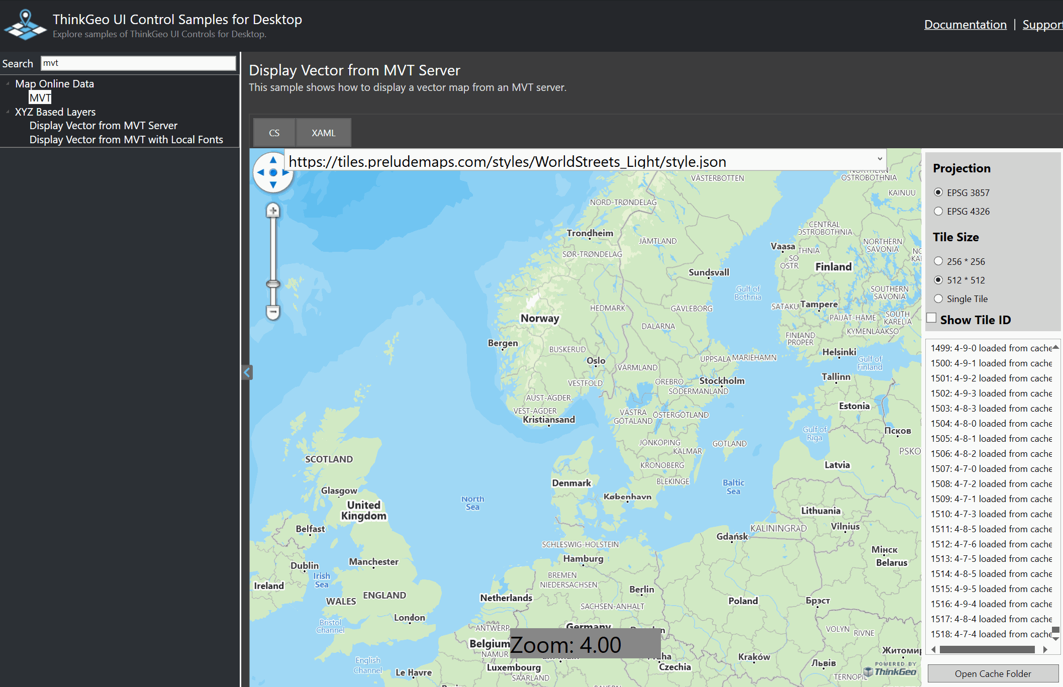
Figure 1 - ‘HowDoI’ samples showing real-time reprojection of MVT data.
ThinkGeo UI 14.4 brings major advancements to the MvtTilesAsyncLayer, making vector tile rendering faster, more reliable, and easier to integrate into your workflows.
Projection Support – You can now reproject MVT layers on the fly, allowing seamless integration with maps in any coordinate system.
Tile Caching – Added caching capabilities dramatically improve performance and responsiveness, especially for maps with frequent pan and zoom interactions.
Improved Robustness – Numerous stability enhancements ensure smoother performance, reduced memory overhead, and more reliable rendering in demanding applications.
You can see the enhanced MvtTilesAsyncLayer in action by downloading our ‘HowDoI’ samples for Desktop, Mobile or Web.
Improved WFS (Web Feature Service) Support
Version 14.4 delivers major upgrades to the WfsV2FeatureLayer, expanding compatibility, flexibility, and reliability for users working with OGC-compliant data sources.

Figure 2 - ‘HowDoI’ Sample showing a WFS layer of Parcels in Helsinki.
MultiPolygon Geometry Support – The layer now handles complex MultiPolygon geometries, enabling more accurate rendering of advanced spatial datasets.
Smarter URI Handling – Improved URI flexibility and automatic axis-order detection ensure seamless integration with a wider range of WFS servers and projections.
Enhanced Reliability – General stability improvements lead to more consistent performance and fewer connection-related issues.
New Drag-and-Drop Events in WinForms
ThinkGeo UI 14.4 introduces expanded drag-and-drop functionality to the ThinkGeo.UI.WinForms namespace, giving developers finer control over user interactions within map applications.
Newly supported events include:
DragDrop – Triggered when a drag-and-drop operation completes on the map.
DragEnter – Fires when an object is first dragged into the map area.
DragLeave – Fires when an object leaves the map area during a drag operation.
DragOver – Continuously fires as an object is dragged over the map surface.
These additions make it easier to build interactive and intuitive map editing tools, such as dragging files directly onto the map.
Continued Commitment to CAD and ODA Support
As part of our ongoing commitment to CAD developers, ThinkGeo UI 14.4 continues to stay fully aligned with the latest Open Design Alliance (ODA) updates.
These updates ensure that our CAD layers remain compatible with the newest DWG and DXF formats, allowing seamless integration with leading design and engineering workflows. Building on the foundation we introduced in our previous CAD and ODA announcement, this release further enhances stability, performance, and fidelity when visualizing complex CAD drawings within ThinkGeo maps.
By maintaining close alignment with ODA advancements, we’re ensuring that ThinkGeo users can confidently incorporate CAD data into their GIS applications — bridging the gap between engineering precision and geospatial insight.
We Welcome Your Feedback
We hope you found today’s post useful. If you have questions or topics you'd like us to cover in future posts, we’d love to hear from you! Email us at sales@thinkgeo.com or schedule a meeting to talk in person. We always enjoy connecting with our customers, learning how you’re using ThinkGeo, and exploring new ways to improve our products.
About ThinkGeo

We are a GIS software company founded in 2004 and located in Frisco, TX. Our clients are in more than 40 industries including agriculture, energy, transportation, government, engineering, IT, and defense.
We pride ourselves on our excellent service and transparency. ThinkGeo offers a variety of products and services to meet almost any GIS application need. We can even help you develop your next project - anywhere from a few hours of consulting to outsourcing an entire project. To learn more, email us at sales@thinkgeo.com, or call us direct at 1-214-449-0330.