
ThinkGeo Cloud Geocoder goes “Global”
The range of application for a high performing Geocoding utility is within the developer’s control. From simple data analysis/visualization and customer management to distribution techniques that give you the edge over your competition. When addresses are geocoded the immediate benefit for users, whether novice or professional is that the data can be visualized and then analyzed which can lead to greater depths of data immersion and deduction.

Reverse Geocoding in ThinkGeo Cloud
Knowing where you are and what’s around you was once an area only experts and roadmaps could help you with. In the last 20 years it’s safe to say a mapping revolution has taken place and now typing in what you’re looking for near you is commonplace. ThinkGeo Cloud’s Reverse Geocoding API lets you quickly convert coordinates from anywhere in the world into human-readable streets addresses. It also allows users to get a list of nearby points of interest and to find the nearest place of any category you want; again with global coverage.

Routing and Service Area Functionality Comes To The ThinkGeo Cloud
ThinkGeo’s next addition to its robust cloud offering is ThinkGeo Routing, and it’s already here! Not only can you now get driving routes and turn-by-turn directions from our cloud, we also added a Service Area utility to help you manage business logistics using spatial analysis.

ThinkGeo S-57 Nautical Charts Viewer
ThinkGeo has given its nautical chart support quite the overhaul. Our newly-improved Nautical Charts Layer reads and displays S-57 Electronic Navigational Charts (ENC) from the International Hydrographic Organization, and integrates with our GIS UI controls so you can display those charts in your own applications. This new layer can also read and apply style information defined in an S-52 file. Best of all, it’s 35% faster than our previous-generation Nautical Charts Layer!

A Look Ahead at ThinkGeo Cloud
With a major .NET evolution around the corner; ThinkGeo is primed to make the most of the latest environment enhancements. Our library of SDKs are being re-written to take advantage of the technological climate ahead of us, and will support .NET Core 3.0 natively when the new version of Microsoft’s development framework launches in the fall. ThinkGeo Cloud uses our SDKs as its main engine, which means that our Cloud services will be more performant, more responsive and more memory-efficient.

Using the ThinkGeo UI Control for WPF in Your WinForms App
The ThinkGeo UI control for WPF is designed to produce professional-grade GIS applications, delivering maps with higher performance and responsiveness than our control for WinForms. But did you know that ThinkGeo’s WPF control can be used to enhance your WinForms apps as well?
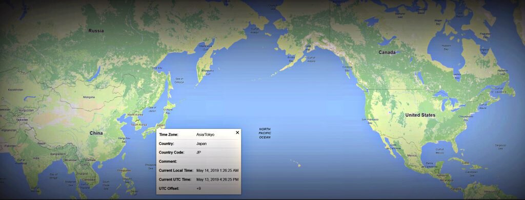
ThinkGeo Cloud’s Time Zone API
ThinkGeo has added a Time Zone API to our growing list of Cloud services. The importance of knowing what time zone different parts of the globe fall under is paramount in business. Whether its managing your fleet of vehicles that are spread out across continents or optimizing when you send messages out to business partners, the flow of productivity is crucial. If the product/service you provide can be globally consumed then your audience is the world and something as simple as knowing what time it is can go a long way.

ThinkGeo Cloud Enhancements
The latest version of ThinkGeo Cloud has been released. Registered ThinkGeo accounts will notice the changes immediately. Once logged in to ThinkGeo Cloud users will be met with a slideshow tutorial covering all of the Cloud basics.

ThinkGeo’s Vector Map Library is now using WebGL
The latest release of ThinkGeo.js vector map library will be using WebGL. WebGL (Web Graphics Library) is a Javascript API that is used to display 2D and/or 3D graphics and it is fully supported in today’s most popular web/mobile browsers. With all of ThinkGeo’s maps being rendered using WebGL developers can control how and when features are drawn on the screen and in turn will experience increased performance with their map rendering.

ThinkGeo Vector Maps
A sure fire necessity in GIS map creation is that you’re going to need a basemap. Basemaps provide the canvas for your artistry; they allow for an immediate visualization of the geographical area you want your focus to be on and provide a background for the implementation of your data.

ThinkGeo’s 2019 U.S. Retail Closings Map & How We Built It
To create this map, we first gathered and aggregated U.S. store closings from major retailers like Sears and Family Dollar, who have issued these as simple lists of addresses. We then used a process called geocoding to convert those addresses into geographic coordinates; ThinkGeo offers both a cloud-based geocoding API and an embeddable geocoding component for .NET that can process thousands of addresses in seconds.

Getting Technical: ThinkGeo Drawing Performance
This ThinkGeo WPF performance sample can render 16,000 count of rectangular shape features ; then it will distribute the shapes throughout 4 layers evenly. After clicking the [Start] button the sample application will update 1,600 rectangular shape features per 1,000 milliseconds, the time lapsed of the features being drawn will display in the application footer. Evaluators of the sample can modify the update rate, update features count, and enable or disable the layers.

Give Your Maps a Lift with ThinkGeo Cloud Elevation
Elevation data can have many practical uses in a variety of industries; from agricultural to urban development. Slope and aspect can be directly derived from rendering elevation points and getting precise feedback. ThinkGeo Cloud makes it easy to get that feedback.

ThinkGeo’s Color Generator & How We Built It
Using ThinkGeo Cloud’s Color Generator anyone can begin creating a visual map that highlights the data you want to use! Color is arguably the most important aspect of map creation and we’ve created a fun and easy to use generator to give you the head start you need. ThinkGeo’s Color Generator is included in our 60-day Free Evaluation of ThinkGeo Cloud.